Names and Games
Toponyms, days & Paving Stones
We’ve had a couple of letters asking about the geography of Nea, the planet that features in jjhudsson’s latest novel Other Places Which Also Are the World’s End. We suspect one of them is actually from the Storyteller himself, since it is written in his own hand - on the back of a photograph of a patio paving stone taken outside the Tricky Genre Press - and bears no stamp. The other is from Tulip’s mother.
Both correspondents touch on the nomenclature of the supervaporous regions on Nea’s solar facing surface, while the former appears to offer a startling insight into the journey made across the planet by the hero Menlo and her companion, September Deal.
Do you know your Argonne from your Ulm?
If you haven’t read the EPUB yet, ‘supervaporous’ is the term used in Other Places to denote continent-like areas of land that rise above the miasma of the Cloud Well (Ed. see our Tricky Words blog for a glossary of Nea terms). There are eight of these regions on Nea. They each have a rather unusual name, the origins of which are not explained in the novel. Here they are depicted on the map that is presented at the beginning of the novel:
Map 1. Planet Nea. An infra-red satellite image of Nea, in the constellation Gydda 1969b (Image The Tricky Genre Press).
If you are used to the exotic-sounding names bestowed upon the universe by the International Astronomical Union, such as the Sea of Tranquillity (on our moon), Minos Linea (on Jupiter’s moon, Europa), or Leviathan Petera (on Neptune’s moon, Triton), we admit that Cottonopolis sounds a bit limp; and why anyone would name a celestial freckle Belgdamsvej is anyone’s guess.
“I get Heligoland,” begin’s Tulip’s mum. “It’s got the word ‘land’ in there, so that’s a give-away. But Roughton Heath? That’s near Cromer, isn’t it? What’s it doing in space?”
Good question, Tulip’s mum. The answer is that all eight are the names of places associated with famous physicists. Perhaps the most well-known is Heligoland, the archipelago in the North Sea where Werner Heisenberg worked out the Uncertainty Principle which underlies quantum theory. Argonne is named after the Argonne National Laboratory (Illinois, USA) where Maria Goeppert Mayer worked on the structure of the nucleus, for which she shares a Nobel Prize. We won’t spoil your fun by giving the answers to the others. (Ed. but if you’re stumped, you can find them in the notes to the annotated version of Other Places).
Nothing like the sun
The second question relates to the map presented at the beginning of the novel. This map, purporting to be based on a satellite image of part of the solar facing surface of Nea, shows the approximate course taken by our hero, Menlo, and her accomplice, September Deal, as they go in search of the enigmatic Tringley, whom, it is said, has established a rebel base on or near Roughton Heath. The map marks certain events that take place on the journey, all of which are covered in the story.
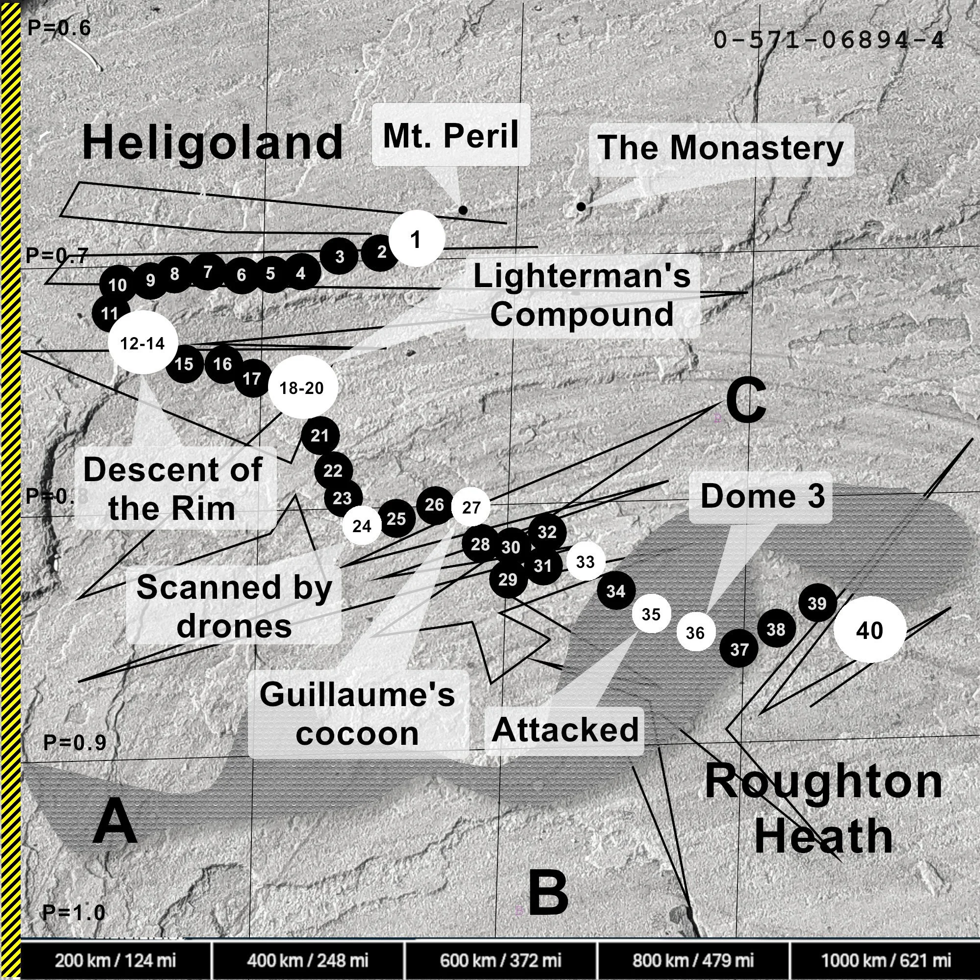
Annotated satellite image of Nea solar-facing surface, showing route taken from the Domes to Roughton Heath (in Nea days), and certain events thereon: A (the Pressure Wall); B (outer extent of Ice Lens); C (black lines = locational variance in the ALTAG sample). Image: The Tricky Genre Press.
“What is a ‘Nea day’?” asks Tulip’s mum. (Ed. referring to the image caption giving distances ‘in Nea days’) .“And what are those little black lines supposed to be?”
This - much like Ma Tulip’s attention - is all to do with drift. The opening of Part Two of Other Places (aptly sub-titled ‘Water’) sets out the problem:
“I have mentioned that Nea is tidally locked, meaning that one side of the planet always faces our sun, Gydda. It is this phenomenon that gives rise to Nea’s unusual light-cycle, a feature which is best addressed before we enter the Cloud Well; for once we have left Heligoland, distance travelled will have little meaning - we will measure our journey in light…”
Human settlement on Nea is on the ad lucem surface; that is the solar-facing surface. If you are following the astronomical argument, that ought to mean constant daylight. If Earth shared this set-up it would mean twenty-four-hour days, and the appalling concept for our nocturnally minded readers of no night whatsoever. However, things are not as stark as that on Nea. Thanks to a planetary libration (Ed. a minor oscillation in Nea’s spin) there are periods when the lateral margins of the solar-facing surface are sometimes more, and sometimes less, in direct confrontation with Nea’s sun. This circumstance leads to a subtle yet noticeable dimming of the surface light over these lateral areas. Thus, while there is no formal day-night distinction, such as one recognises here on Earth, there is, nevertheless, a sequence of lightness.
As Nea wobbles, luminescence over the rimlands progresses from bright daylight to a murky grey and back again over a period of sixteen Earth days. In the novel the Neah called this sequence a light-cycle. It can be thought of as a unit of time existing somewhere between a week and a month on Earth. The residents of Heligoland divide the cycle of light into six Nea ‘days’ which, for reasons of familiarity, are given the names of Norse gods - just not the ones we are used to here on Earth. Would the Boomtown Rats have had a hit with I Don’t Like Hadegris, we ask ourselves?
Zigger-zagger - Ah!
And what about those zig-zagging lines? The answer lies in palangats, geodysphoria and verivectors - terms, most of which you can find defined in our Tricky Wordsblog. September Deal expresses the problem neatly in Chapter Four:
“For most of us, the geophysical concepts surrounding navigation and location science are straightforward. September Deal likened it to a chessboard - a grid with cells. Anything on it has a unique reference, an X and a Y coordinate. Latitude and longitude, if you like. Either way, one set of co-ordinates tells you where anything on that board is. Now imagine placing another chessboard on top of the first one. This one is transparent, so the chess pieces can pass through it. Provided that the two boards align with one another, the coordinates for your bishop are the same on both boards. But suppose you shift that second board to the left or to the right, up or down, just a little, by a cell or two? Even though the bishop hasn't physically moved - it’s still on the same square on the first board - its coordinates have changed on the second board. So now you have two sets of co-ordinates, two different ways of locating the same bishop. Which one do you use? You see our problem. Now add a few more chessboards on top of the first two, willy-nilly. Some are warped, some have wrinkles, some are thicker in parts; a few may even be upside down. Imagine this, and you're getting close to Nea geolocation: on Nea that one bishop can be in a dozen different places all at the same time depending on how you measure it…”
Thus, the sharp black lines on the satellite image depict a ‘corridor of uncertainty’ within which the ‘actual’ route travelled by Menlo and Deal lies.
Paving the way?
This question of uncertainty brings us back to the opening statement of this blog, that there is a ‘startling insight’ to be revealed about the satellite image itself. It is to do with that photo of a patio paving stone we mentioned. Does it look familar?
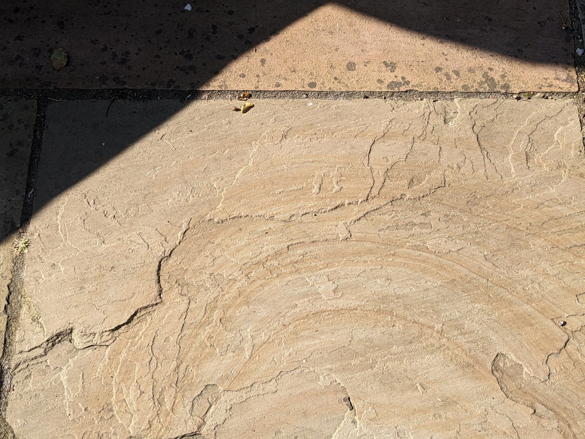
Photograph of a paving stone. Image: Anonymous?
Notes
Information on Werner Heisenberg and Maria Goeppert Mayer based on their Wikipedia entries (July 2026).
The annotated EPUB version of Other Places Which Also Are the World’s End will be available shortly on the Tricky Genre Press website.
All Images © The Tricky Genre Press 2026.